
From Outer Space to the Climate Crisis: A Rébuffat Photo as a “Witness to Glacier Retreat”

Updated: Jul 27
Nearly 70 years after Georges Tairraz took his famous photograph of Gaston Rébuffat, Noa Barrau and Jean Rouaux tracked down the exact location in the Mont Blanc massif. But as they tried to recreate the original framing, they discovered that several of their reference points had disappeared.

Eyes fixed on his phone, Noa Barrau compares the landscape with the original photograph. He thinks he has found the spot where Georges Tairraz stood to capture Gaston Rébuffat on top of a rocky pinnacle. But the frame does not line up. Several of the landmarks the young photographer had chosen—sections of glacier and hanging seracs, unstable towers of glacial ice—are no longer visible. To reconstruct the image, he has to imagine where the ice would have been nearly 70 years ago.
Finding the Pinnacle
In the original photograph, Gaston Rébuffat stands atop a slender rock spire, four coils of rope in his right hand, with the glaciers and peaks of the Mont Blanc massif behind him. Taken by Georges Tairraz, the image was selected by NASA in 1977 as part of a collection intended to show life on Earth to a potential extraterrestrial civilization.
Noa Barrau, a 23-year-old photographer and filmmaker, had been thinking about recreating the image for more than a year. He brought in Jean Rouaux, a 24-year-old alpinist who also grew up in the Chamonix Valley. Barrau was initially drawn to the photograph’s composition, framing, and period technique. Rouaux was more interested in the man at its center. “It was the person in the photograph who always inspired me,” Rouaux told us. “He made me want to go up there myself and take the idea all the way—to actually step into the photograph.”
« Les gens peuvent penser qu’on s’est arrêtés sur une course classique, qu’on a rapidement fait la photo et que c’était terminé. En réalité, on n’était même pas sûrs que le gendarme existe encore »
Noa Barrau
In May, while lingering snow still made the climb impossible, the two began preparing. They put together a project file, studied the approaches, and searched for the clothing and equipment they would need for the recreation. Their first challenge was locating the scene precisely. The photograph is often associated with the Aiguille de Roc, but it was actually taken on a lower subsidiary summit known as the Pic du Roc. The location is poorly documented, and the two Chamonix locals did not even know whether the pinnacle had survived the rockfall that regularly reshapes the massif.

They flew over the area twice by paraglider to identify the formation. Two additional flights allowed them to land at the base of the route, carry some of their gear to the Tour Rouge bivouac, and establish caches. Their final approach began on foot from Montenvers, carrying 45- to 50-liter packs. For Barrau, that logistical work is the least visible part of the project. “People might think we stopped during a standard alpine climb, quickly took the picture, and that was it,” he said. “In reality, we weren’t even sure the pinnacle still existed.”
From the bivouac, they took about four hours to reach the spire. Their speed came from years of experience. Rouaux has climbed since childhood and operates in the 5.13 range, while Barrau spends much of his time in the mountains and is highly skilled in both paragliding and high-altitude photography. But their efficiency on the route says little about the preparation required. They postponed the project several times because of moisture, clouds, or uncertain weather windows. They could only recreate the photograph under skies clear enough to match the lines and colors of the original.
On the day they chose, the sky was blue, but winds of roughly 20 miles per hour swept across the ridge. To get into the right position, Rouaux had to repeat the final section six or seven times. The top was narrow, and he could not remain standing on the pinnacle for long. Between attempts, he lay back down on the rock and waited for the wind to ease. Barrau, meanwhile, had to hold his camera by hand because he had not brought a tripod. He needed to wait until “the framing was completely steady, Jean had all four coils of rope in his hand, he was looking in the right direction, and there wasn’t a gust.”
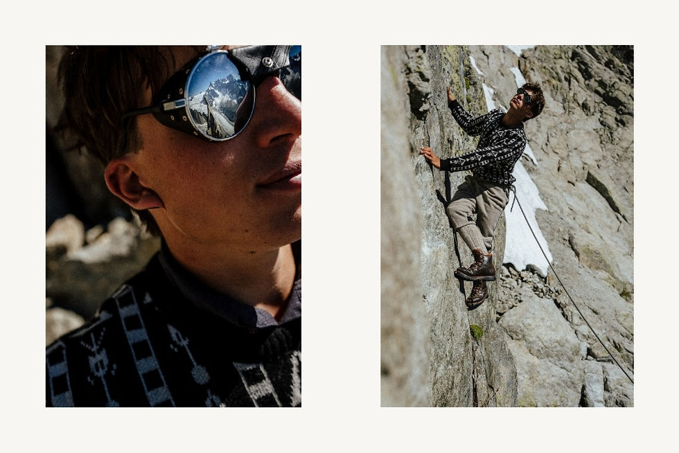
They assembled the clothing with help from Jean-Franck Charlet, a Chamonix mountain guide and crystal hunter. The pants, socks, and boots were all vintage. The sweater was a recent reissue of a model similar to the one Rébuffat wore. The boots even surprised Rouaux, who had expected them to feel mostly heavy and stiff. “I didn’t expect them to grip so well,” he said. “You put your foot on a tiny edge and it holds. When I switched back to my modern mountaineering boots, I was almost a little disappointed.”
« Les points de repère que je m’étais fixés étaient des zones de glacier et des séracs suspendus. Certains avaient disparu »
Noa Barrau
Historical accuracy ended where safety required it to. To reach the ridge, the two used a modern climbing rope, passive protection, and quickdraws. Rouaux also hid a harness beneath his pants and remained tied into it. A second knot around his waist recreated the rope system visible in the original photograph. Using a hemp rope, he said, would have been “not very smart,” especially for the rappels, or controlled rope descents. Their goal was instead to “respect the look of the period while combining it with modern safety standards.”
Protection on the final section was still limited. Rouaux worked out the moves on his first attempt, then repeated them until he knew the sequence precisely. Once they had the photograph, the two still had to descend unbolted terrain with no established rappel stations or fixed anchors. The descent took nearly as long as the climb.
What the Image Reveals
To recreate Tairraz’s framing, Barrau divided the original photograph into four sections. In each corner, he looked for a landmark: a ridge, a summit, a section of glacier, or a hanging serac. He found the photographer’s position fairly quickly. He also identified the focal length: a 35-millimeter lens, common at the time and one Barrau regularly carries in the mountains.

n theory, all he had to do was move a few inches forward or backward. But for about 30 minutes, he could not make the two images line up. “The reference points I had chosen were sections of glacier and hanging seracs,” he explained. “Some of them had disappeared. I had to find new ones and imagine that a certain rock matched a spot that would have been under the ice 70 years ago.” As he reconstructed the frame, he realized “how much had disappeared.”
« Nous avons un devoir de protéger cette montagne que nous aimons tant »
Jean Rouaux
Any comparison between the two photographs has limits. The exact date of the original image, the amount of snow on the ground, the light, the weather, and the color processing all affect how the landscape appears. The photographs alone cannot provide a scientific measurement of the retreat of each visible glacier. Still, some changes are clear. In the newer photograph, the glacial surface appears less continuous, and several seracs visible in the older image are gone. For Rouaux, the difference is unmistakable. In the photograph of Rébuffat, he said, “the glacier almost forms a continuous blanket of snow across the entire landscape.” In the photograph taken in June, the scene looks “much grayer, with more moraine, a more fragmented glacier, and several masses of ice that have disappeared.”
During his research, Rouaux also learned about Gaston Rébuffat’s concern for protecting the mountains and the natural world. He believes the alpinist would have been glad to see one of his photographs become “a witness to glacier retreat,” rather than serving only as a historical tribute. It is also a reminder, Rouaux added, “that we have a duty to protect this mountain we love so much.”


